ROADBOTICS DEPLOYS SMARTPHONES AND AI TO ACHIEVE BETTER ROAD MONITORING
Hank Walshak, Contributing Writer
 RoadBotics is making it easier, less costly, more objective and safer for governments to maintain and repair their road infrastructures. For example, Detroit’s infrastructure is 2,660 miles. Monitoring this infrastructure by RoadBotics included the use of a smartphone and artificial intelligence to observe and report on road conditions.
As Ben Schmidt, PhD, President and Co-Founder of RoadBotics explained it, the RoadBotics approach beats traditional in-person road inspections that can be dangerous by requiring inspectors to walk along or stand on a roadway. This leaves them exposed to the dangers of vehicles passing by, some at high rates of speed.
“We completed a photographic appraisal of the entire Detroit infrastructure in days instead of weeks,” said Schmidt. He has led product development at RoadBotics since its inception three years ago.
Since then, under Schmidt’s leadership, the company has accrued 200 government clients, including cities, townships, municipalities and counties.
In 2016, North Huntingdon Township, Pennsylvania, was falling behind on its pavement-management system. At the same time, the township was seeking a faster road-survey option to help plan its five-year program of road management. After careful research, North Huntingdon Township partnered with RoadBotics in 2017 as the first RoadBotics customer.
Governments use the RoadBotics product, RoadWay, to empower cities to assess roads using artificial intelligence (AI). “We automate inspections and generate objective, actionable data about road networks. Governments use RoadWay to plan and prioritize maintenance needs so they can fix the right roads at the right time,” Schmidt points out.
“We completed a photographic appraisal of the entire Detroit infrastructure in days instead of weeks,” said Schmidt. He has led product development at RoadBotics since its inception three years ago.
In working with clients, RoadBotics engineers first obtain a map of a city’s or government’s infrastructure. They then set out by car or truck and use a smartphone to photograph road conditions throughout the complete infrastructure. This photographic input is then analyzed by artificial intelligence. Doing so produces a detailed report on the conditions of the infrastructure.
In the RoadWay process, algorithms assess every 10-foot section of road. The assessment is affordable, stretches budgets further and is delivered quickly, said Schmidt. RoadWay helps clients to visualize, plan, budget and produce an effective data set.
RoadBotics is the brainchild of Dr. Christoph Mertz, a Co-Founder of the company. While working on autonomous vehicle sensors at Carnegie Mellon University, he asked, “Can the same image processing and AI technologies used to navigate autonomous vehicles be used to evaluate the conditions of the roads on which they travel? And, could we use a simple smartphone to do it?”
The answers to these questions was, “Yes.” Several years later, Dr. Mertz developed deep-learning algorithms that could evaluate road images captured by a smartphone and refined using A.I. The goal: Give everyone responsible for roadways complete infrastructure transparency.
RoadBotics monitors roadways cost effectively and efficiently by automatically and precisely identifying and rating a wide array of important roadway features and conditions.
“In effect,” said Schmidt, “the smartphone turns any car or truck into a sophisticated mobile sensor. With this app, drivers simply attach their phone to a dash mount, giving the phone’s camera a full view of the road ahead. This data is then uploaded for automatic analysis by an AI-driven cloud platform.”
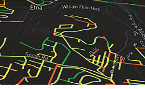
He added that the video data, with the smartphone’s other sensor capabilities, allows RoadBotics to calculate a wide variety of vital and established roadway metrics. The RoadBotics red, yellow, green web accessible visualization map gives managers using RoadWay comprehensive and near real-time status of their roads.
All of which is just the beginning for RoadBotics.